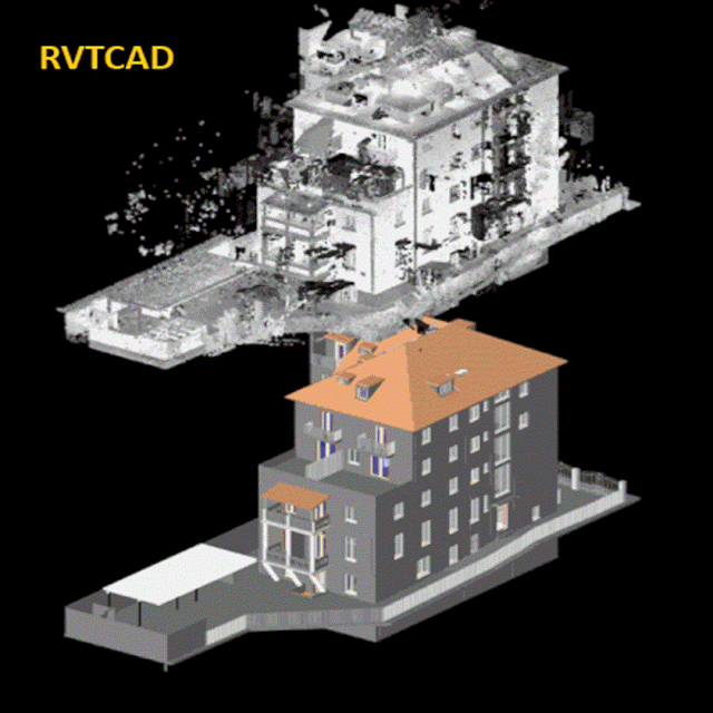
Introduction:
In the realm of architecture, engineering, and
construction (AEC), the utilization of point cloud data
has become paramount for accurate and efficient project execution. With the
advent of advanced technologies such as laser scanning and photogrammetry,
capturing precise as-built conditions of structures has become more accessible.
However, the challenge lies in effectively translating this raw point cloud
data into actionable models within Computer-Aided Design (CAD) software and
Building Information Modeling (BIM) platforms like Autodesk Revit. Here, we
delve into the best techniques for seamlessly integrating point cloud data into
CAD and BIM workflows in Revit.
Comprehensive Data Preparation:
Before embarking on the conversion process, thorough
data preparation is essential. This involves cleaning the point cloud data to
remove noise, outliers, and irrelevant details. Software tools like Cloud
Compare, Autodesk Recap, or Leica Cyclone offer functionalities for data
filtering, decimation, and alignment, ensuring a clean and manageable dataset
for further processing. enable precise alignment of scans and seamless
integration of multiple datasets. By meticulously refining the point cloud
data, practitioners lay a solid foundation for accurate modeling and analysis
in subsequent stages of the workflow.
Precise Registration and Alignment:
Accurate registration and alignment of point cloud
data are fundamental for maintaining spatial consistency throughout the
modeling process. Utilizing robust registration algorithms such as Iterative
Closest Point (ICP) or automated feature-based matching techniques ensures
precise alignment of multiple scans. This step lays the foundation for coherent
and accurate modeling in CAD and BIM environments. This step lays the
foundation for coherent and accurate modeling in CAD and BIM environments.
Additionally, verifying alignment through visual inspection and quality checks
guarantees the integrity of the registered point cloud data, minimizing errors
and discrepancies in subsequent modeling tasks. Integrating ground control
points or reference markers further enhances registration accuracy, enabling
seamless integration with existing CAD and BIM frameworks.
Feature Extraction and Segmentation:
To enhance efficiency in modeling, extracting relevant
features from the point cloud data streamlines the process. Automated feature
extraction algorithms can identify structural components such as walls,
columns, and beams, facilitating rapid modeling within CAD software.
Additionally, segmentation techniques allow for the isolation of specific
elements, enabling focused modeling efforts and reducing clutter within the
point cloud dataset.
Utilization of CAD-Compatible Formats:
When transitioning from point cloud data to CAD
environments, selecting compatible file formats is crucial. Industry-standard
formats such as LAS (Lidar Data Exchange Format) or E57 (ASTM E2807 Standard)
ensure seamless integration with CAD software packages like AutoCAD. These
formats preserve the integrity of point cloud data while enabling efficient
manipulation and editing within the CAD environment.
Adaptive Modeling Strategies:
Incorporating adaptive modeling strategies is
imperative when translating point cloud data into BIM models in Revit.
Leveraging Revit's native tools for modeling architectural, structural, and MEP
components streamlines the process and ensures compatibility with BIM
standards. Additionally, utilizing parametric modeling techniques enables the
creation of intelligent BIM objects that possess inherent relationships and
data-rich attributes.
Iterative Refinement and Validation:
The conversion process from point cloud to CAD and BIM is
iterative by nature, requiring continuous refinement and validation. Iterative
refinement involves revisiting the model, refining geometric details, and
optimizing parameters to achieve greater accuracy and fidelity. Concurrently,
validation processes such as clash detection and tolerance analysis ensure that
the resultant models adhere to project requirements and standards.
Integration of Metadata and Attributes:
Augmenting BIM models with metadata and attributes
derived from point cloud data enhances their utility for downstream processes
such as facility management and asset tracking. Incorporating spatial
coordinates, material properties, and maintenance information enriches the BIM
model's data ecosystem, empowering stakeholders with comprehensive insights
into the built environment.
Collaborative Workflows and Coordination:
Effective collaboration among multidisciplinary teams
is essential for successful BIM implementation. Establishing streamlined
workflows and coordination mechanisms ensures seamless information exchange
between stakeholders. Platforms such as BIM 360 facilitate real-time
collaboration and version control, fostering a collaborative environment
conducive to efficient project delivery.
Conclusion:
In conclusion, Rvtcad the integration of point cloud data into CAD and BIM workflows in Revit presents immense opportunities for enhanced accuracy, efficiency, and collaboration in the AEC industry. By employing best practices such as comprehensive data preparation, precise registration, adaptive modeling strategies, and collaborative workflows, practitioners can unlock the full potential of point cloud data and harness its transformative capabilities in the digital era of construction and design.

Comments
Post a Comment